


Charts
BASIC INFORMATION
IENC (Inland Electronic Navigational Chart) Maps for inland sailing are considered standardized in structure, format and content.
In Poland the only one institution that is authorised to issue IENC maps is Office of Inland Navigation in Szczecin. The produced maps are intended for use in electronic map display devices and Inland ECDIS navigational information.
IENC maps contains neccessary informations for safe navigation. Thanks to the extra included informations it significantly improves the comfort of navigation. To ensure the safety of navigation, IENC charts should contain the following set of data:
- coastline,
- shore structures that pose a danger to navigation,
- contours of locks and weirs,
- fairway boundaries,
- fairway axis with mileage/hectometre,
- navigation aids such as: ponds, buoys, lights and navigation marks,
- isolated dangers
Thanks to the implementation of RIS (river information services) on the Odra section: from the motorway bridge in Świeck to Szczecin and on the section of the Warta river from Kostrzyn (near Odra) to Świerkocin, users of waterways can use inland electronic navigation maps on these sections free of charge.
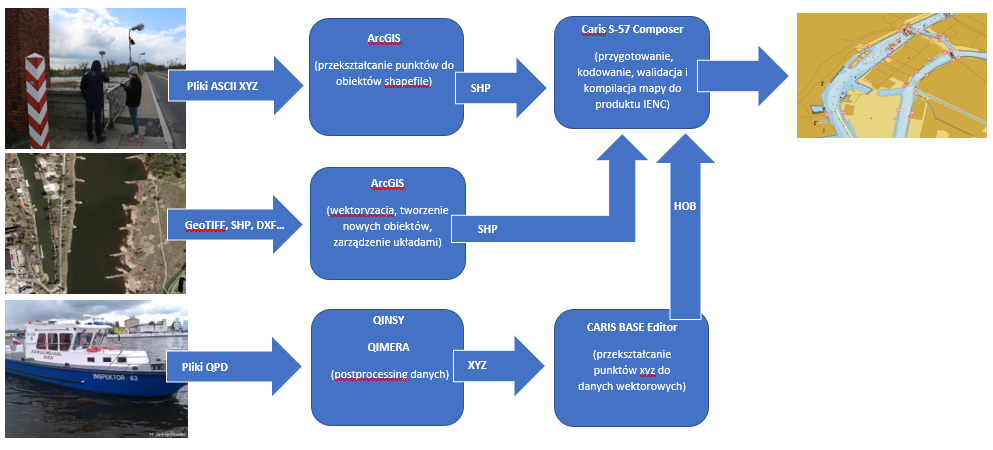
The process of developing IENC maps made available by the Office of Inland Navigation in Szczecin:
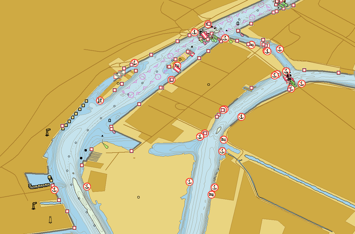
Picture below represents electronical navigation map of Szczecin:
ECDIS INLAND
Electronic Chart Display and Information System ECDIS (Electronic Chart Display and Information System) is a navigation information system that integrates an electronic navigation map and information from navigation measurement sensors on one display. The system installed on the vessel supports the navigator in planning and controlling the route.
Inland ECDIS is an extension of the ECDIS standard where special requirements for IENC Inland Electronic Navigational Charts are included. The system shall be capable of presenting radar image and map data on a common display which shall be consistent in range, position and orientation.
| TYPE OF VARIANT | DESCRIPTION | IMAGE |
|---|---|---|
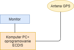
| Minimal variant |
PC + monitor antenna GPS software for ECDIS |
 |
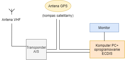
| Variant using AIS |
PC + monitor antenna GPS (satellite compas additional as a direction indicator) software for ECDIS AIS transponder with VHF antenna |
 |
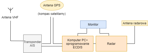
| Navigation variant with usage of AIS and radar |
PC + monitor antenna GPS (satellite compas additional as a direction indicator) software for ECDIS AIS transponder with VHF antenna radar |
 |
TERMS OF USE
TERMS OF USE OF INLAND ELECTROIC NAVIGATION CHARTS (IENC)
I. Everyone can use Electronic Inland Navigation Charts (IENC) free of charge for visual, information and navigation purposes. It is unacceptable to use IENC maps for purposes other than those indicated.
II. The entitlement to free use of IENC maps means only the possibility to view its content in applications intended for viewing IENC maps or for navigation.
III. Copying and editing the content of IENC maps, as well as possible subsequent recording and dissemination of the copied/edited content, is possible only with the written consent of the Office of Inland Navigation in Szczecin.
IV. The Inland Navigation Office in Szczecin reserves that, despite due diligence, the data contained in the IENC maps may not correspond to the current factual and legal status, and therefore may be inaccurate, incomplete or out of date.
V. The Office of Inland Navigation in Szczecin is not responsible for the effects of decisions made on the basis of IENC maps.
VI. Any requests or changes to the maps should be sent to: ris-odra@szczecin.uzs.gov.pl
RANGE OF IENC
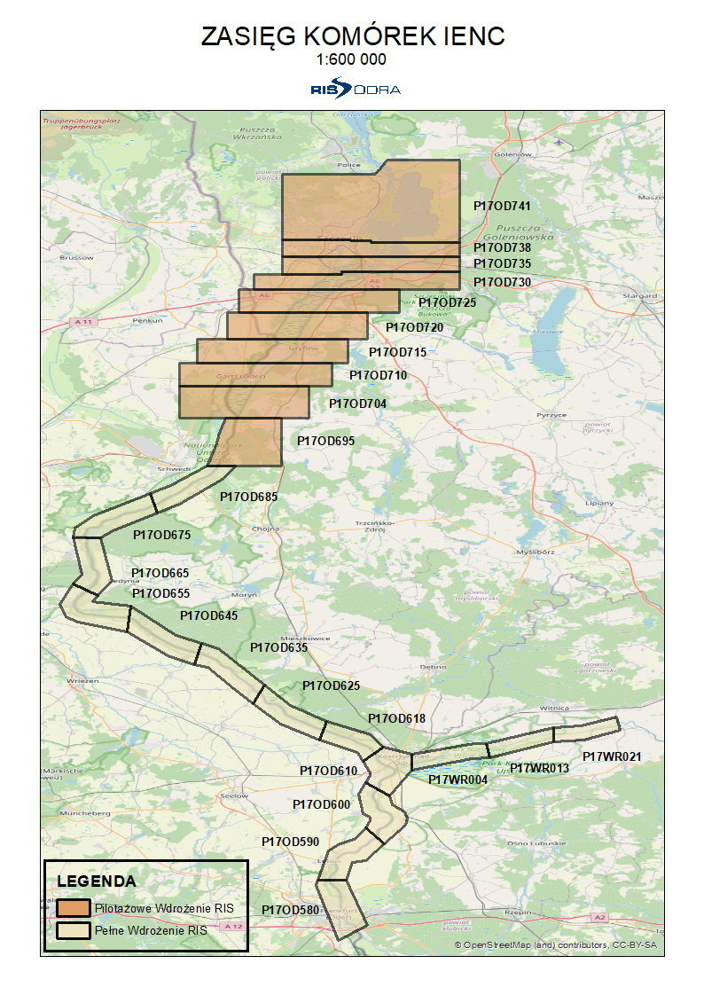
Maps were made in a standard format of *.000 for ECDIS application.
The published inland electronic navigational charts for the area covered by RIS (river information services) on the Odra and Warta rivers have been prepared in the official file format, adapted to be handled by Inland Electronic Chart Display & Information System (Inland ECDIS). To view the content of maps (IENC) you need specialized software that supports a given file format in the 2.3 and 2.4 standards.
At the same time, we would like to inform you that the producers of Inland ECDIS systems provide free specialized software that allows you to view maps (IENC) also on personal computers, laptops, etc.
Software could be downloaded from: https://www.sevencs.com/products/software-downloads/ or http://www.teledynecaris.com/en/products/easy-view/